| Oct 17/13 to Nov 09/13 | Hike Horseshoe Bay to Midway |
| Nov 10/13 to Nov13/13 | Hike Midway to Castlegar |
| Mid Nov/13 to April 14/14 | Stayed put in B.C. |
| April 15/14 to May 2/14 | Fanny Bay to Port Hardy |
I’ll start this section by saying something about the walk and my equipment. I don’t keep track of mileage but the google mapping software I use (under the ‘Map’ menu) has it as 732 kilometres. The walk took 26 days so an average of 28 km per day. My longest day was 46 km. I should be saying backpacking, not walking, as a walk with no weight is a simple stroll compared to hiking with a forty-pound pack. At the least, that extra weight can cause blisters even when shoes fit well. I had three in the first few days that band-aids took care of, and no other issues with anything hurting after that.
For gear I took my bigger tent, but avoided using it whenever I could get under any kind of a shelter or simply use my poncho as a fly. I use a Luxury-Lite cot that I rate five star. It keeps me off the ground and I get the same sleep every night. I have a Big Agnus Storm King down sleeping bag. It’s rated for 0 Fahrenheit but I’m sure they mean 0 Celsius. It’s a great summer bag but for comfort when it’s freezing, long underwear, at the very least, is needed. Better yet why not just crawl in with the same clothes worn through the day. I use a silk bag liner sheet that’s easy to wash and keeps the bag itself clean.
The same fellow who invented that cot also came up with a Luxury-Lite backpack. That one gets one star. It has a hip belt separate from the backpack. The belt has a notch on the backside that the pack sits on. What that does is put all the weight low at the centre of your back, unlike every other backpack’s hip belt that distributes the weight all around your hips. With forty pounds on that hook it pulls your hips back to the extreme and makes your thigh bones feel like they’re going to pop forward out of their socket, meanwhile the buckle of the belt is forced into your abdomen. I compared it to what a few cranks on the medieval rack likely felt like. I was only able to walk about 200 feet with weight on the belt. I only used it to relieve the weight on my shoulders every kilometre or so for as long as I could stand it. To be fair, he does say it’s not intended for loads of more than thirty pounds. The pack itself only weighs two pounds. I have since thrown away that belt and attached a tump strap to that back. That is simply a nylon guitar strap that allows weight to be carried with the head. The voyageurs used them as do the Sherpas who call it a namlo. I add one now to every backpack I own. They are very simple to add but they should be included with every backpack.
My food supply was no different than what I used with the bike and canoe. A porridge mix for breakfast and a pasta mix for supper with trail mix and bars for calories throughout the day. I use a Solo alcohol burner for a stove which can also use small pieces of wood as fuel. Hope to Tulameen took four days, and Naramata to Beaverdell took three. There was nowhere to buy food in between. I never ran out of the porridge mix but on those two sections, I emptied the pack of everything else eatable. Water was not easy to find through the Myra Canyon section with the major creeks too far down in the canyons to be accessible. For two days, from Chute Lake to Hydraulic Lake, there were only three creeks. Two of these were more trickle than creek but they allowed me to finally cook a meal.
Is long distance walking boring? At times, but boring maybe isn’t the right word. Long straight sections, and some were miles long, are ‘non stimulating’ but when there are turns in the trail, and the view is changing, the miles and the day pass by quick enough. There’s no joy in walking highways but that was only necessary through the Lower Fraser Valley. I wouldn’t have made the trip if highways were the only route option.
The hike started in the middle of October and ended mid November so night fell before I was wanting to stop and most days I kept going for an hour or two in the dark. I didn’t take my solar panel and to conserve my headlight batteries I used it’s red light setting which gave just enough light to see a few feet ahead.
It was snowing the night I arrived at Chute Lake. There’s a lodge there and I told myself if it was open I’d get a room. Well the lights were on, so I assume I could have had a room, but there was also an old railway shed beside the tracks. I had to dig away the dirt that prevented the sliding door from opening which meant it hadn’t likely been entered in years. It was clean enough though and served as shelter that night. I spent the next night under the kiosk sign board marking the beginning of Myra Canyon. About five inches of snow there. The following night I reached Hydraulic Lake (formerly McCullough Lake … sorry Andrew, the Kelowna area has a number of lakes that have somehow acquired new names and yours is one of them.) I was tired and hungry and not at all looking forward to spending a night in the snow. I noticed the sign for the Kelowna Nordic Ski Club and wondered if they might possibly leave the door to their clubhouse unlocked. I didn’t have much hope that they would, but I gave it try. Mixed feelings when it opened, relief for sure but questioning too if it was OK to pull a Goldilocks. Leaving a donation eased those concerns. The cabin had a wood stove plus, on the table, a new two litre bottle of water, which meant no need to walk to the lake. I was reluctant to use the bought water, as at best I could only replace it with lake water, but, like Goldi, I was plenty tired and figured my need trumped not using it. Spent a very restful warm night and used the stove to cook a filling supper and breakfast. Turned out the water belonged to two roofing contractors who showed up in the morning expecting to make coffee. I soon enough had the bottle refilled with lake water.
The next day was a 46 kilometre day. I was out of grub by the end of it and had to make it to Beaverdell. I left the rail trail on a logging road that accessed the highway and then walked for more than two hours in the dark to Beaverdell, arriving just before the only store closed. Beaverdell has no motels but I was told of a cabin that could be rented. A pricey cabin at $70 but I guess I’m not a fan of sleeping in the snow. The next three nights; north of Rock Creek, in Midway, and Grand Forks, I spent at the home of friends who had worked for Pope & Talbot, when I was a GPS contractor and who I hadn’t seen for eight years.
The railroads east and west of Midway in 1915 were not owned by the same company. The Kettle Valley Railway ran to the west and the Columbia & Western Railway ran east. The C&W was in use before the turn of the century-long, before the KVR was completed. The C&W was built as part of a rail network owned by J.J. Hill an American, whose rail lines came to B.C. to access the resources of the Kootenays … and haul them across the border to Spokane.

Rock balancing artwork along the trail. There were others but I deemed this one the winner because of the railway spike in the design.

This is Cascade Canyon, which is located west of Christina Lake. The Kettle River in this November picture is at a relative trickle to the way the water flows through here in June.


These two are of Cascade Canyon during high water when I visited in June of 2006.

A former railway tool shed fixed up by the local trail group for the use of hikers. This one up from Christina Lake.

Another rail trail cabin thanks to the efforts of the local trail group. This one was west of Grand Forks. It was here that I discovered that I was not alone on this trail. The cabin’s logbook had an entry by Dana Meise who was heading west. Dana is on a mission to be the first person to walk the entire Trans Canada Trail. When he stopped here, he was en route to Victoria, which he reached in December of 2013 completing a journey of 16,000 kilometres. I later learned that we were both in Rock Creek at the same time although we never met. Likely we were both off the trail, looking for groceries. In 2014 Dana will be doing the section of the TCT that runs from Edmonton to Inuvik. The Mackenzie River is part of the trail and he’ll be canoeing there. We may meet yet.

From Rock Creek to the Paulson Creek bridge I was shadowing the route I had biked with the canoe earlier in the year. This photo looks down on one of the two sections of the highway that were too steep to ride. Unlike the highway, the rail bed starts climbing west of Christina Lake and continues at a very steady shallow grade all the way to the summit of the mountain range ahead. Two things stand out from that. First the engineering and survey work of one hundred years ago was as capable as it is today albeit now the process is much simpler. Second is the incredible amount of ‘cut and fill’ this constant even grade requires. Not just for this pass but on the entire railway. And consider that strong backs were what moved most of that fill.

Looking back on the even slope of the rail grade, and the fill necessary to achieve it, as it climbs to the Paulson Summit. The depth of snow also increased as I approached the summit, making my steps much more tedious. I knew of a logging road crossing near the summit and had thoughts that I might have to abandon the rail grade and use that road to access the highway. There was a foot of heavy snow at the top and I wouldn’t have been able to continue on the rail grade except that east of the logging road crossing, vehicles had used the rail bed and I was able to walk easily enough in their tracks.

The Paulson Bridge as seen from the rail grade.

The rail grade as seen from the Paulson Bridge – this one from earlier in the year..

This was another long day. I kept going till ten o’clock wanting to reach Bulldog Tunnel. It’s a half mile long and aside from being snow-free, I thought perhaps a quarter mile of rock might offer some insulation from the freeze. It didn’t. I judged what I thought was halfway and slept there. Had the company of a black rat during the night who was welcomed with a rock lobbed his way. He respected my space after that and I left him a spoonful of porridge in the morning.

Yup, that’s exactly what you think it is. Seems I was more than half way through the tunnel when I stopped for the night. Happy to be below the snow line upon emerging too.

I didn’t keep track of how many tunnels I passed through on the entire trip – easily more than a dozen I’d say.

Lower Arrow Lake from the rail trail. Odd that when I paddled up the lake I could make out the railway cut and I took pictures of a couple of the visible trestles. Until then I didn’t even know this rail-trail existed and never imagined that I’d be looking down on the lake from it months hence.
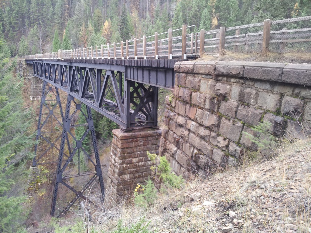
I was impressed by the stonework along the C&W railway. Not only these footings but the massive stone walls used in more than a dozen places to support the railbed where it crossed small draws.

A closer look at the rock wall construction. Not likely these rock blocks were made on site. I would think they were commercially produced and shipped here. As the railway originated in the States perhaps they are American-made. Although that assumes they were part of the original railway built in the late 1800s and they could be from a later date. Perhaps the original railway had wooden trestles across all these now-filled draws. The blocks are about 2 foot by 3 and were used in walls up to thirty feet in height. None of the walls show any signs of deterioration

Looking across Arrow Lake at the boat launch ramp where I put in to paddle up Arrow Lakes. That was June and the water level was at the bottom of the ramp.
Leaving the trail just north of Castlegar. I’m a fan of walking poles. Properly used they provide push that the legs have to keep up with. On hills, you get the equivalent of four-wheel drive.
