| Aug 17/16 to Oct 10/16 | Cycle and Paddle Dunster, B.C. to Saskatoon |
| May 1/17 to Oct 5/17 | Paddle and Cycle Saskatoon to Fort Frances |
| May 13/18 to June 1/18 | Paddle and Cycle Fort Francis to New Lowell |
When I look back on my 2017 paddle I’m glad I’m not a planner. Just do it as it comes and take any problems in stride when they arise. Otherwise, I would have had reason to feel overwhelmed by what was ahead. Beyond the Saskatchewan River, I was going to have some very potentially nasty large lakes to deal with. Lakes with potentially nasty winds that is. (Lakes, without winds, are rather serene – ask a fish.) I would have the choice in Manitoba to paddle south on either Lake Winnipeg or Lake Winnipegosis and then into Lake Manitoba. I had heard of the Boundary Waters but wasn’t even sure they were on my route, so I had given no thought to the two dozen portages they would require. Next would be Lake Superior, the world’s largest lake. I’d be thirty days hugging its northern shore before I figured the stakes were getting too high and I’d opt to cycle instead to reach Lake Huron. A much smaller lake, that I had never heard of, was also planning to team up with my constant nemesis, the wind and stop me from saying what I had been able to say since the beginning of the trip. That I had never had a wave that came close to having me capsize.

The canoe, with all my gear, spent the winter wrapped in tarps, sitting on a pallet in a Saskatoon commercial storage yard. I spent the winter doing volunteer work in Haiti. Here I’ve cycled a short distance to reach the river and I’m in the process of getting everything shipshape for another season’s paddle.

A stop of interest four days downriver from Saskatoon, Batoche, a former Metis community. At this site in 1895, Metis and First Nations people led by Louis Riel were defeated by a much larger contingent of government forces. https://en.wikipedia.org/wiki/Battle_of_Batoche
Walking to the site from the river I encountered a large number of wood ticks. Only one tick bite resulted and it was easily accessible at my waistline. I had a bottle of permethrin with me and put it to use treating my clothes for future encounters. That also made me more tick aware and I took precautions before entering tall grass like tucking my pants into my socks.

The confluence of the South and North Saskatchewan Rivers. At Rocky Mountain House, near where I first put into the South, the two drainages are only about 30 kilometres apart. The rivers then separate by as much as 300 kilometres crossing the Prairies. The North would have been a shorter route for me and it was the chosen route for the fur trade voyageurs. As the photo shows, the South is the cleaner river. I was drinking water from it unfiltered but found other sources once the rivers combined. Another obvious change was the huge slabs of ice, not yet melted, that had been pushed high onto the shore all along the river bed. There had been no similar blocks of ice on the South Saskatchewan’s shores

My track entering Tobin Lake, a hydroelectric reservoir on the Saskatchewan. Up until now my travels down the river had been rather blasé but I had only started up the lake when the wind began to pick up significantly. I’m not good at retreating but I certainly wished I had turned about instead of taking on this blow. The third arrow on the above map sits just below a small bay. I pulled into the tip of the point at the entrance to that bay and ran the boat into some reeds, then sat there waiting for the wind to lessen. It didn’t, and after about an hour I decided that I would try and make progress up the shore but stop at the first available spot. The bow was pointing upriver though and before I could head down the lake I had to somehow get turned about. That is not easy when you’re solo and seated right at the back of an 18 foot canoe. With the help of reeds at the head of the bay, I eventually managed to get facing the right direction. The wind and waves were coming at about a two o’clock position from my bow. I soon learned of another major problem. The water in the reservoir had dropped a couple of feet from its full pool level and everywhere the banks were steep for that two foot distance. I could get to the shore, but with the waves, there was no way I could disembark and get the canoe ashore without it being swamped. The load in the canoe made pulling it up such a bank not possible, even without the wave action. I had to find a bit of beach. It was three hours before dark when I set out and I was confident that I’d find a spot eventually. Three hours later and the only certain eventually was the approaching darkness. I had to stay away from the shore up to about 100 metres, due to the wave action from the returning waves, bouncing off the bank, compounding things. Soon it was too dark to see that distance clearly and a couple of times when I thought there were possibilities I paddled in closer to check but no good. At some point, a wave caught me broadside and I don’t know how I managed to not capsize. I say that the boat is like a cork and it proved that many times on my travels up the BC coast. Never had I had a time when I said ‘boy that was close!’ Now I certainly know of one time – and it’s been the only time – where that’s been true. I was now ready to admit I had no choice. I was going to have to get the boat ashore and deal with events as they unfolded. Except for the dark, I could have kept going and I was reluctant to give in. Something very strange then happened. It seemed to me that the canoe was swinging like a compass, and pointing to a particular spot on the shore, despite my reluctance to surrender to an anywhere will have to do, type landing. I headed for that spot ready to deal with whatever the steep bank caused to happen. As I got close though I could see a bed of floating wood that I hoped might support the canoe while I unloaded. Closer yet and I was seeing not floating wood but wood sitting on sand! It was a beach! It was still touchy getting ashore there because I can’t simply run the bow up onto the beach and expect the stern to not fill with water in the time it would take me to get out of the canoe. Running the bow higher only means the stern sits lower. I have to, at the last possible moment, swing parallel to the beach, disembark quickly and haul the stern up first. In waves like this, it’s not possible to manage that without some water getting in the boat. A small price to pay considering all that could have happened, that didn’t happen that night. The map shows my landing spot. Three hours of paddling to get three kilometres. (The tracker didn’t respond to my movement after my time spent sitting in the reeds, hence the straight line connecting to my location the following morning.)
A thought about why the boat didn’t capsize. It happens so quickly that you don’t have time to consciously react. The reaction that is needed is to keep your torso upright and do that instantly. The canoe tips but you don’t. Kayak paddlers learn a technique called bracing, where the paddle is used as an outrigger to stop any roll. I don’t know if that’s possible from a canoe, being that the seat is higher above the water. If it is, it’s not something I’ve practised. I don’t think my reaction time is quick enough to make it work. I would not have had time to do it this night.
I was involved with another tippy canoe incident years earlier and this time I did end up in the water. It was a ‘war canoe’ that a local museum had, and it held about ten paddlers. The outrigger club was asked to try it out one day. It was an incredibly tippy boat. We’d likely gone half a kilometre when somebody made a wrong move (hope it wasn’t me!) and over we went. I and two or three others found ourselves in the water. Amazingly the others, still in the boat, reacted quickly enough that the boat didn’t capsize. One paddler mentioned that she had tipped so far that some of her hair was wet, yet she managed to stay in.
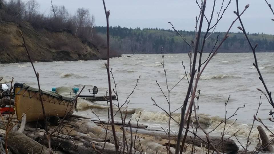
I will forever look at this picture and say what a lovely lovely beach! My landing spot after a harrowing episode on Tobin Lake. This picture was taken the next morning with the lake still in a bit of a stew. The lumpy tent spot I found was home for two nights. I was happy to accept blasé again once below the dam.
Another event that happened, or I should say didn’t happen while I was getting around the dam is worth telling too. I landed at the boat launch and met a fisherman. He offered to bring his quad in the morning and tow the canoe past the long sluice to a site where I could access the river. I was ready for him, with the cart wheels attached, when he showed up, not with his quad, but with his car. A car with no trailer hitch and no place to tie anything to. Easy enough I thought and suggested we open the hatch and I would just sit there with my feet hanging out and hold the bowline to pull the canoe along. I thought this was best as I could watch the canoe and tell him if there was a need to change anything en route. Once we started rolling I realized that my weight alone sitting on the smooth flooring in the hatch was only borderline adequate to keep me attached to the vehicle. I should have somehow roped myself to the back of his seats. Any extra drag on the wheels of the cart might have pulled me right out of the vehicle and onto the roadway – to then be run over by the canoe, no doubt! (Extra cheek pinch at such times didn’t add much to the cling!) It was an eight kilometre drive and it took better than a half-hour. Hindsight on that episode says I should have asked him to stop while I made myself more secure.

The ‘Old Channel’ fork of the Saskatchewan River. I had been warned that it might not have adequate water in places and that the main river had more flow, but all went well and it was a very pleasant paddle. Here, I am only a day upriver from Cumberland House, Saskatchewan’s oldest European settlement. It was first settled in 1774. Its location was a crossroads for all cross Canada water travel – to the far north via the Methye Portage, to Hudson’s Bay via Lake Winnipeg and the west via the Saskatchewan Rivers.
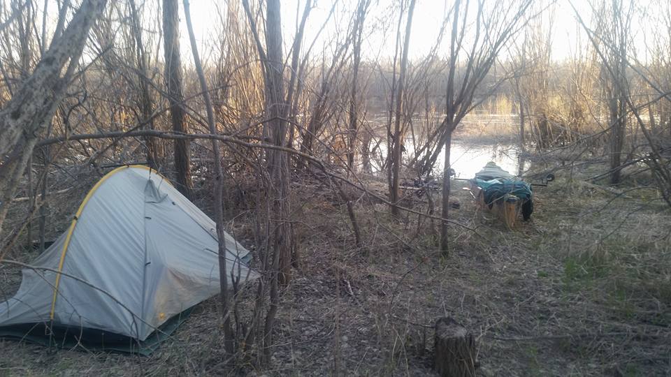
A secluded camp spot near Cumberland House. I didn’t require any supplies but spent the better part of a day on a wander into town. A chance to have a conversation with somebody other than myself! It’s been a very lonely river. The next town is The Pas, Manitoba, three days downriver.
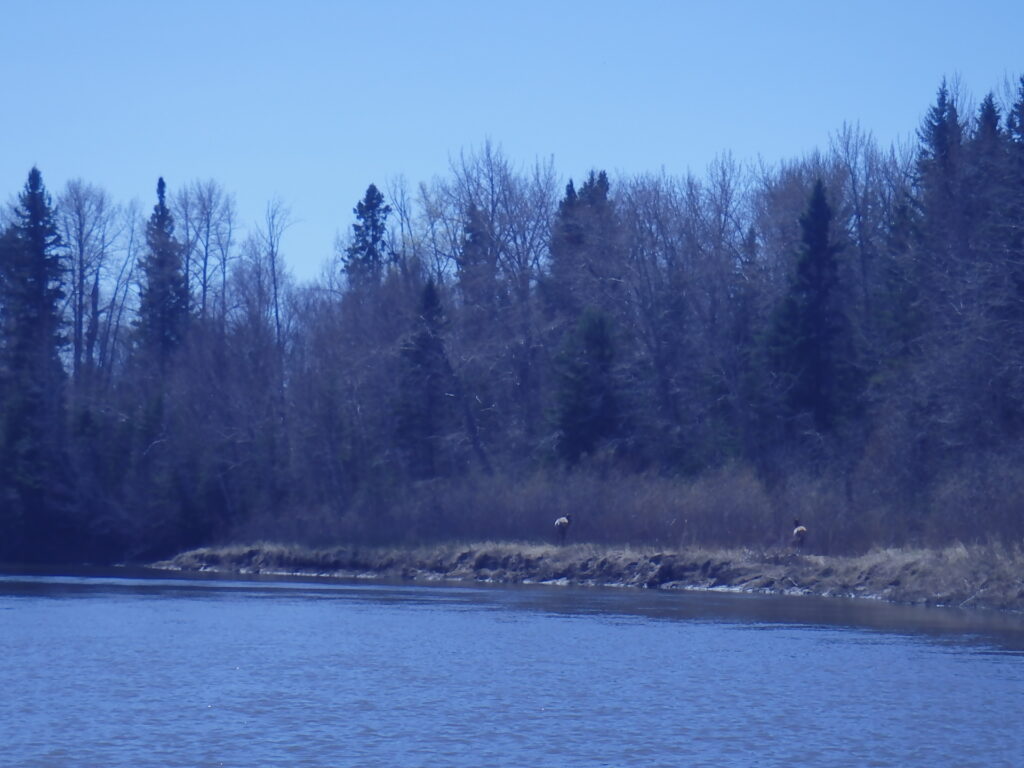
A glimpse of a couple of elk shunning the opportunity to have their picture taken. Here the river banks are low but further downstream they are made of rather sandy soils and are as much as five metres high. They are constantly being eroded which results in trees being undermined, causing them to eventually let go and slide into the river. One such slough had the perfect timing to let go right beside me. I was only about twenty-five metres from the shore when I heard the crack of breaking timber and saw the ground let go. I quickly turned the canoe away not knowing how high the wave might be, but it was only a foot or so in height. A wake-up call to be mindful of the river banks.

I’m fighting a headwind as I travel further down the river. Usually, a wind means no rest unless you go ashore. Otherwise, when you stop paddling the wind is going to spin the canoe so the bow is downwind. The reed grass along the river though provides an alternative. Just ram the bow into the weeds and take a break. I was wanting to get further along though as a passing boater invited me to spend the night at his cabin. That wasn’t to be. The winds increased and I luckily found a path through the reeds that led to a very good camp spot. I was windbound there for two days.
I never did get the opportunity to stay at the boater’s cabin but further downstream, on another windy day, I spotted a ramshackle-looking cabin that I ducked into so I could make my supper, out of the wind, before continuing downstream. While I was eating I kept hearing a rattling noise coming from the stove pipe. Thinking it was the wind I ignored it for a time but eventually opened the stove door to check inside. One very grateful blackbird, who had somehow managed to get down the chimney, emerged from the stove. No doubt an even blacker bird but none the worse for the ordeal.

The Saskatchewan River terminates at Cedar Lake but in a very weird fashion. For the last five or so kilometres you are in the lake but still in the river. The main branch of the river is defined by reedy banks but they are narrow and the lake is visible on both sides. When you finally emerge into the lake proper you are well away from any dry land. I had read that canoeists looking to find the entrance to Saskatchewan should use GPS to locate Kettle Island. On the above map, Kettle Island is the last bit of ‘land’ south of the obvious north-south running main river channel. All good I thought, some dry ground to spend the night on before I start across Cedar Lake. But not the case. There was no dry ground on Kettle Island. After nearly an hour of back and forth along its banks and a few stops to check further inland I settled for next best. I did what I could to add reed matter under the tent. I also pushed a stick into the mud so I could gauge whether or not the water was rising during the night. Cedar Lake too is a reservoir. I pulled the canoe up beside the tent, in the event a middle of the night quick evacuation was required due to rising water. Not necessary though and the next morning I headed south hoping to soon be done with soggy Cedar Lake. Cedar Lake though was in no hurry to bid me farewell. My desired course was due south and once I was around the peninsula, shown by the red marker on the above map, I would be on the southern shore of Cedar Lake.
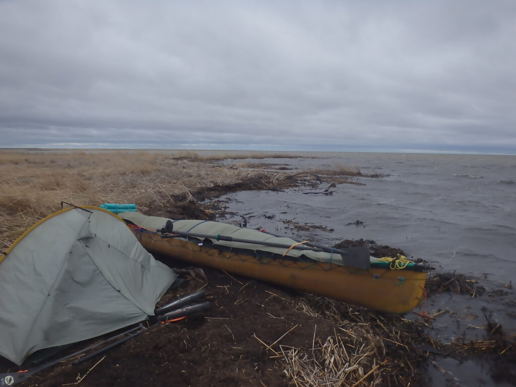
The red marker also marks this location. Soon after setting out on this five kilometre crossing the winds picked up from the northeast and try as I would I was unable to gain any headway east to get around the point. Instead, the winds dictated that this would be my landing spot. Drier than my previous night’s spot at least. The tent is beside the canoe, not only for what wind shelter it might offer but also because the reed matter piled on the beach is the only dry place available. The following day I was able to pick a route through the marsh with enough water to either paddle, pull or pole the canoe through and I didn’t have to attempt to paddle around the point. But that day ended even sooner than this one. Again the winds drove me ashore, but this time after only about four kilometres.
I rarely took videos but this short one tells it like it was on Cedar Lake.

Two days wind-bound at this spot but at least it had some trees. It would take me a total of five days to cover the seventy kilometres of Cedar Lake crossings and shoreline. From the south end of Cedar Lake, there was a gravel road that lead to Highway 60. Once there I had notes that told of a trail to access Lake Winnipegosis. When I discovered that trail didn’t exist the only option was to assemble the bike and pedal south. Thinking about the days spent wind-bound on Cedar had me saying that I would skip Winnipegosis entirely and pedal instead to Lake Manitoba.
Cycling meant that I would be towing all my equipment. It was unlikely that I’d be able to ship anything not needed, ahead by bus. At least the road ahead was mostly flat but I did have concerns that the weight was too much for the canoe cart. But those concerns, along with the overweight gear, were about to be lifted from me. I was on the highway for less than thirty minutes when a vehicle stopped ahead. People often stop, wanting to know more about my journey or just for a picture. During our chat, I learned Adam lived in Winnipeg and was homeward bound. That had me asking him if he might be willing to haul all my unneeded things and store them until I arrived. That’s asking a lot because it also meant delaying his trip by at least half an hour while I packed things up. Very grateful that he consented to do that. Thanks, Adam and thanks for the four cold beer too! The hospitality also was extended to include a bed for two nights when I arrived in Winnipeg.

I hadn’t cycled too far before I realized that I had two broken spokes. I had spares though and repairs were simple enough. But then I discovered that the spares, sold to me by the bike shop when I bought the bike, were too long! Better than too short though, because I was able to bend them around the hub. This fix lasted until I reached Winnipeg. I have fixed many broken spokes on the road with all the cycle touring I’ve done but never considered this as an option. This method would also work in a pinch with simply a piece of strong enough wire and the existing broken spoke. No wheel or tire removal required.

Manitoba highways are very stingy with their pavement. Rarely were the shoulders paved. The loose gravel is barely rideable and in places dangerous, because if you leave the pavement with too much speed, the gravel could cause you to upset. Further north it didn’t matter, as there was very little traffic, and I could pretty much stay on the pavement all day. I would only pull onto the gravel when I had cars meeting me from different directions at the same time. Eventually, the traffic was heavy enough that it was necessary to get off the pavement every few minutes. Closer to Winnipeg the shoulders became rideable again.

The canoe cart is tough on tires. Hank William’s lyrics describe it well “My tubes and tires are doing fine, but the air is showing through”. With only a spare for the bike, I luckily managed to make it to St. Martin Jct where I safely left the canoe and hitched 70 km to buy new tires.

There’s a small grocery store in St. Martin Jct run by a family of Korean origin. They were quite taken with my travels, posing for pictures with the canoe etc. I bought some groceries and took a side road six kilometres to the lake, where I camped for the night. At some point, I was awoken by the sounds of a vehicle and then I heard my canoe tarp rustling. I was in a total grog but must have grunted or something as I did hear a voice say ‘sorry’. On awakening in the morning, I was wondering what that was about. Was somebody wanting to steal my stuff? Quite the opposite, beside the canoe, were two bags of corn chips and some bars with a note from the family wishing me well on my journey. Assume they found my location from my tracker and came after the store closed. Very nice.

The Tribar Ranch in Manitoba Lake, looking like a Caribbean Isle. While I was changing the tires I received an invite from a local rancher to come stay at his place. His ranch though was out on a peninsula in Manitoba Lake. I intended to paddle Manitoba Lake anyway but I would have stayed along the east shore. Reaching this ranch required an eight kilometre lake crossing. Hindsight says that was a foolish crossing. I couldn’t see the far shore when I set out. The wind was blowing from the north, down the lake, and there were already foot-high waves. There were no whitecaps and the wind was not forecast to get any stronger. But who says prairie winds on a summer day are going to stay as forecast. Not good too because the wave pattern was already formed. Any extra wind would quickly make the waves larger. I reasoned though that if it did start to get too rough I could turn downwind and eventually pinch my way back to the east shore. When you’re out in the middle of such a crossing though you realize this is not a good place to be. At least by then the far shore was visible and getting closer. No thanks to ever trying that again.
Big thanks to Arvid and Debbie, for the invite to come for visit. I enjoyed great, feel-at-home hospitality, plus washed my clothes, slept in a bed and played a bit of guitar with the family all singing along. They invited me to stay longer but the forecast was now saying that two days on, the winds would be too strong. The next day favourable winds got me to ‘The Narrows’ where I took out and switched back to pedalling.
Winnipeg is behind me. It is not fun pulling an 18 foot canoe through city traffic. There is no other option but to travel through the city. The only way to cross the river is to go through the city. I must say though that all the drivers, that I did stupid things in front of, were very kind to me. Proving what it says on their license plates, ‘Friendly Manitoba’. Once I even started down a one-way street going the wrong way. The traffic stopped and allowed, very sheepish feeling, me to get turned around.
Shortly after crossing the bridge, I noticed a bike store selling Dahon folding bikes. I stopped and asked if they would like a photo of one pulling an unusual load. That stop resulted in a conversation that kept me there for nearly an hour. I chanced to meet a good friend of Don Starkel’s, the adventurer from Winnipeg who wrote ‘Paddle to the Amazon’ and ‘Paddle to the Arctic’. If you’ve ever read those books you would know why one of my first questions about Don was, ‘did he have a death wish?’ He accomplished those incredible journeys with what seemed to be no regard for his safety, and with perseverance far beyond what anybody would care to endure. Anytime I get to feeling things are stacking up against me and I’m being tested, I say two words, ‘Don Starkel’ and I know that whatever it is I’m being challenged with, it’s a pittance to what Don endured.
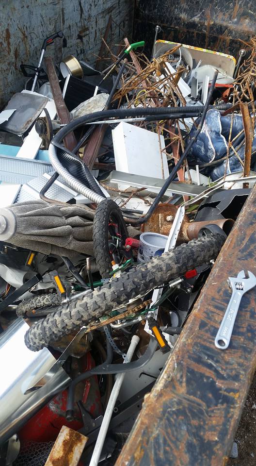
It’s a metal recycle container in a landfill at Falcon Lake. The new cart tires I had put on in St. Martin junction were looking like they weren’t going to get me to Kenora. Passing the landfill I thought it would be worth having a look to see if I might find some used. It was closed but only a bar gate blocked vehicle access. Likely was there for half an hour peering into bins before happily finding two adequate tires in the last bin checked.


An aerial view of Lake of the Woods – Lac du Bois. 14,500 islands in one lake! Including the islands, more shoreline than Lake Superior. In Kenora, at its northern end, I went to the library and used a computer to purchase a digital Canada Lakes map for my GPS. I was going to need it to navigate all the lakes between here and Thunder Bay. I would like to know how the voyageurs found their way on Lake of the Woods. I would think the fur companies would have blazed or somehow marked trees to help navigate this maze. Too easy to pick a possibly much longer other route otherwise. The other photo shows the Turtle Portage railway trolley. The shortcut, it offers boaters cuts off 145 kilometres. It’s boater-operated. Once the boat is on the trolley, crank on the large wheel which operates the cable. I’ve misplaced the picture I had of my up and over.
