| June 20/19 to Oct 25/19 | Paddle & Cycle St. Lawrence River to Nova Scotia |
| May 26/22 to Sept 17/22 | Cycle Newfoundland 2022 |
| Sept 18/22 to Nov 4/22 | Cycle & Paddle Gulf of St. Lawrence to Saguenay |
Previous Next
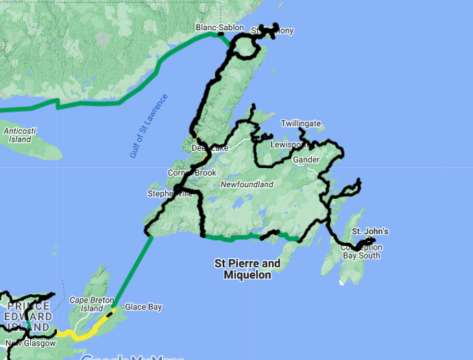
I took the canoe to Newfoundland even though I expected it would not get much use. (Another option would have been to leave it behind in Nova Scotia and pick it up there in the fall.) I had hopes that maybe I could paddle some of Newfoundland’s east coast as the plan was to eventually exit the province via the ferry from the top end of the Northern Peninsula across to Blanc Sablon, Quebec. As it turned out, my total distance paddled in Newfoundland amounted to only 41 kilometres, that being Deer Lake and a tiny bit of the coast. There just wasn’t enough suitable connecting brooks and ponds to make it worthwhile. What water routes there were, were one way. I would have had to pull the canoe with the bike for more than 3500 kilometres to paddle a few hundred kilometres. Instead, I stored the canoe in Deer Lake, and, with the help of the provincial ferries servicing the South Shore, I was able to circumnavigate the entire province with just the bicycle. On my return to Deer Lake, I then towed the canoe north to the ferry. The map shows the route cycled, green being the ferries. Accessing the northern end of the smaller peninsulas along the north coast required travelling the same road both in and out. I was too late in the season to see icebergs but I poked my nose into many small coves hoping I would luck into seeing some humpback whales close to shore. Happy to say that eventually worked.

It is much easier to paddle this load than pedal it! I’m not sure but I think it weighs close to 200 pounds. I can ride up hills of a grade of 6% but more than that, unless they are short, and I am off and pushing. Pushing though does give the body a different stretch. Cycling up a steep grade the low speed is about 4 to 4.5 kph, walking and pushing up the same grade results in a speed only one kph less and there is the added benefit of using different muscles. That speed though is my moving average. On long steep grades the need to stop and suck wind reduces that considerably. Depending on the steepness of the grade I usually count out 40 or 50 steps and then stop for a minute or two while I catch my breath before ‘pushing on’. Some hills would require a dozen such stops. Once I’m off the bike it’s not possible to remount until the grade is reduced to about 2%.

Ready to roll again after two and a half covid delayed years. Big big thanks to warmshower.org hosts Jessy and Charles, of Wysmykal Farms for storing my gear all that time. As for my location for the first two years of covid, I was very fortunate in that I made a last minute decision in January of 2019 to not return to Nicaragua as planned, but instead to make a fourth trip to New Zealand. There I became one of Jacinda’s ‘team of five million’ and we managed to contain the covid that had initially entered the country and in a short enough time eradicate it. During the two years I spent there I estimate my total time wearing a mask was six hours. ( I speak of the Delta variant. The day I left New Zealand the Omni variant escaped from quarantine and spread quickly although, as elsewhere, a much milder covid version than Delta.)

Everything nylon needed a mildew wash being in storage all that time. What the canoe needed most was to be re-coated with epoxy. In 2017 I used ‘West System’ epoxy to re-coat the hull. The ratio of hardener to epoxy was wrong though and that resulted in a dreadful mess. This time I used the same product with better results. By no means professional results though. I chose their quicker setting product and they warn that it has a pot life of fifteen minutes before it’s going to be too thickened to apply. They also warn that any concentration is going to get very hot. The hull now has a decent protective epoxy coating but with white streaks. White streaks that at first I didn’t understand what was causing them. Then I realized the heat was melting the foam roller! Good chance that one day a couple of cans of spray paint will see me paddling a forest green canoe.

My paddle route from Antigonish to the North Sydney ferry. I would have liked to have been able to paddle more of the Nova Scotia coastline but cross winds prevented that. Paddling solo, from the stern of a six metre canoe, it’s not possible to keep the wind from ‘stealing’ the bow once it’s more than a breeze.
When I paddled the Pacific coast I wondered if I might have the good fortune of seeing Orcas from the canoe. I never did. Happy to say I also didn’t encounter any of the creatures that frequent these Atlantic waters in the summer either – Great White Sharks! Their routes can be traced thanks to a tagging program and a shark tracker app which confirmed that we were at least crossing paths.

A very pleasant first day with the canoe finally back in the water. I was able to row thirteen kilometres and paddle seventeen more.

At St. Peters Canal, the entrance to Bras d’Or Lake, after a five day paddle from Antigonish which included one day rain bound in my tent.

Through the lock and into Bras d’Or, an inland sea with locks at both ends due to tidal differences. Like the Trent Severn and Rideau canal systems, the locks are considered heritage and are run by Parks Canada. My thanks to the lock attendant for emailing the photo she took.

Finished with Bras d’Or and, after a short tow with the bike, into Blacketts Lake and the river system that leads to Sydney. A very pleasant change from ocean and large lake paddling.

A not so pleasant portage around a weir where the lake becomes river. A short portage but why the rock barrier? No road here so it wasn’t to stop vehicles.

A camp spot for two days across from the North Sydney ferry terminal while waiting for the ferry to Port Aux Basques, NL.

I am truly excited to finally be able to give this very unique place a good look. Not only do we kinda share a nickname, (The Rock and Rocky) it could be said that we both joined Canada in 1949. My birth year and Newfoundland’s entry into Confederation. First off let’s get the pronunciation right. It’s NewfoundLAND not NewFOUNDland. The electronic reader board in the distance is advising drivers of the current wind speed 30 kilometres up the road in aptly named, Wreckhouse. Check out the flags here, just a slight breeze to Newfoundlanders.

A first look at one of the brooks (it’s brooks and ponds rather than creeks and lakes here) that I’d be drinking from through the summer. The water was always quite brown from tannins but I never filtered any of it and never had any problems.

If it’s going to rain why not camp under a bridge? You’ll stay dry …

… unless the water comes from the bottom. These rocks are where the tent was just a couple hours previous. No surprises during the night but when I was packing up in the morning I noticed that the river was starting to rise rather quickly.

I’ve arrived in Hampden. Further up the coast is Westport. There is no highway between Hampden and Westport. But the map shows a logging road that ends four kilometres from Westport. Surely, I surmised, somebody has cut a trail for ATV’s to allow access between the two towns. Going around on the highway would have been eighty kilometres further and some of that on the, too busy for my liking, Trans Canada. I made a few inquiries and learned that indeed I can make it through, a total distance of about 35 kilometres. Most of it is good logging road too I was told. A mention that I should watch out for coyotes had me wondering how much time my advisors had spent in the bush.

The decent logging road ended after about 10 kilometres. After that I was off the bike and pushing through loose rock more than I was riding. It was a nice change from riding highways though and I had no concerns if I didn’t get through in a day.

After a couple hours of rough going the road improved as did the flora. Now I was able to ride again. The brakes came on hard though shortly after taking this picture. I had just topped a little rise when I ran into these!

Not my picture but it was totally what I experienced. Mama bear and three cubs just twenty metres ahead. A big mama too, easily 300 pounds! Fortunately she was as startled as I was. She never gave her cubs a glance, she just charged off the road and into the bush with cubs in pursuit. Good thing! I pack bear spray and I did have it out, but it wasn’t as ready as it should have been for an encounter like this. If she had charged me as quickly as she ran off, I doubt I would have been able to ready the bear spray fast enough. It was on the top of my gear behind me, held by bungee, with the safety insert in place. I expected she would return once she had the cubs up a tree and I turned about and walked back on the road so as to keep the wind at my back. I figured I’d wait at least ten minutes for her to return but after about five minutes I realized that there were no trees big enough to safely house her cubs. With the safety removed and spray in hand I then walked on by.
After a long day (with my moving average only 6.1 kph) I camped near dark at the start of the quad trail connecting the two logging roads. The next morning though had me biking back four km to find a water bottle that had dislodged from my pack. (It was given to me when I was paddling in Ontario. It’s pink and what have I ever owned that’s pink! I wanted it back!) On my return another bruno encounter. This time our separation was 200 metres and only one cub. She noticed me right away and I hollered expecting her to take flight. She did, but what are the chances – they both went into the bush on opposite sides of the road! I certainly would not be going anywhere until I knew they were reunited. After a few minutes she reappeared but, noticing me, she turned around again and disappeared into the bush. I thought I might have a long wait if the cub had gone up a tree. Another few minutes though and thankfully the cub crossed the road to join her. Lesson learned, at that distance I should have kept quiet and let her make the first move.
The town of Fleur de Lys. It’s at the north end of one of many small peninsulas that jut north. I thought perhaps I could find a suitable viewpoint where I could camp with the hope of doing some whale watching. All too rocky though so I returned to the town. It’s very easy to strike up a conversation with any of the ‘baymen’. When I asked about suitable camp spots I was told of a lovely spot at Coachman’s Cove, in from a junction I’d passed, 13 kilometres back. Then he remarked that he’d drive me there, adding how steep the hill leaving town was. Politely I thanked him but said it was something I was used to doing and would be fine getting myself over there. Nope, he’d have none of that and I realized he wasn’t just being polite and kind with his offer, he really wanted to take me there. As we were leaving town he saw a friend and invited him along for the drive too. All very pleasant, including the cold beer that was produced once we arrived. The camp spot he had it mind was indeed a beautiful spot with a shelter and picnic table. It was in use for a family gathering though. I easily found somewhere suitable nearby. Before long, I had a chat with a couple from the family picnic who strolled past. That resulted in a plate, piled high with fish stew and crab, being delivered to me as well as another beer. All so lovely but alas no whales to be seen.

No whale sightings either from a night camped at Wellmans Cove. Coming out of there I met a Conservation Office driving in. We chatted and I asked for his advise on where best to look for mussels. That I hadn’t been successful in finding any and that I would have liked to add them to my previous nights pasta. I cycled back to the highway and stopped at a fire hall that had a water tap and a picnic table. Except for my morning porridge mix I was out of grub. For lunch I ate my last two bars. A couple of locals on motorbikes stopped by and when we were chatting the CO fellow returned. I surely never told anybody that I was in dire need of food, but must have mentioned to the CO that I was on my last. The closest grocery store was twenty km distant. Next thing, the CO fellow is offering me his lunch. Of course, I emphatically decline his kind offer but the other two start laughing and tell me I am not going to win this argument. I asked him what he was going to do for lunch. He said he was heading to Triton and would be stopping at a cafe for the best $10 chicken dinner hereabouts. I gave him back his apple and a bar and gratefully accepted his sandwiches. But not to be outdone by his kindness I devised a plan. I would go to Triton the next day and try one of the chicken dinners myself. But I would pay for two and request that they provide him with another order the next time he came in.

The next day I arrived in Triton just as it started to rain. There’s a Sperm Whale Pavilion there, that I was planning on visiting. In need of a quick tent spot to stay dry I stopped at the closed pavilion and went around to the ocean side hoping to find a grassy spot to erect the tent. Better than that, the design of the building provided a sheltered nook. I had only just pushed the bike into the dry when I heard a humpback blow. Looking out I discovered what I reckoned were at least ten humpbacks feeding on capelin.
Check out the feeding action of these whales in this short video. It continued like this for an hour and a half! Wow, did I ever luck into a whale show! They stayed close enough to shore the entire time that you could hear their breathing. I came to Triton to buy a couple chicken dinners not expecting to find whales here. The Pavilion attendant mentioned that it wasn’t often that they had whale sightings here.

A very common sight along Newfoundland highways. Stacks of firewood, cut during the winter and left to dry through the summer. The government allows those needing firewood to fall and cut green trees. Winter snow and snowmobiles or quads provide a means of skidding the logs to the highway where they are bucked and stacked until they are dry and lighter to transport. You might be wondering, what about theft? All that work and your pile might one night disappear. Rest assured that would never happen in Newfoundland, their culture wouldn’t allow that. Under the tarp that’s a snowmobile left unlocked for the summer too. As I did at this location I sometimes camped adjacent to the wood piles. The sawdust from all the cutting made for a smoother tent site.

Another permitted road side use of public lands by private individuals. Where the soil at the side of the highway was good, private vegetable gardens were a common site. This was especially so at the top of the Northern Peninsula. Like the wood piles there is no registering of the site to a specific person. Do some work at the site and it’s yours to use. The fellow who ‘owned’ this one lived ten kilometres from the site. Newfoundland has no deer. There are moose and caribou but neither is likely to want to munch on garden vegetables hence the fences are more likely just a barrier to prevent the crop from being trampled.
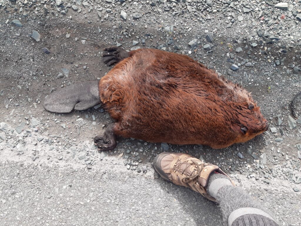
It’s a beaver of course and it’s on the side of the Trans Canada Highway. Road kill but because that is not obvious I have included the picture. I have seen lots of them over the years from the water but have never appreciated how big they can get. Newfoundland also has mink, lynx, black bear, and hares but there are no snakes, raccoons, porcupines or cougar. Polar bear are occasional visitors. When I was at Coachman’s Cove, mentioned above, I was told of an incident where a polar bear had to be shot in the town. It had drifted on an ice floe, from likely a long ways north. It was spotted in the town in the morning when the school kids were on the roads so euthanasia wasn’t an option.

I didn’t think this was possible! I had had a scratchy throat for about four days and because I had test kits with me I decided to rule out that it was possibly covid. I was always a mask wearer whenever I was in a store or not eating in a fast food restaurant. I could only have got it while eating in a fast food restaurant . At the time I would have been triple vaccinated and the somewhat scratchy throat remained my only symptom.

It’s the lighthouse north of the town of Twillingate. I was camped here when I discovered that I had covid. (See the bike? Find the tent?) A few days earlier I had hit a bad pothole that damaged the sidewall of the rear tire. It wasn’t a car size pothole. It was only a bit bigger than baseball size but big enough that I couldn’t avoid it when I did suddenly notice it. With all the weight on the rear tire it broke the cord in the sidewall such that it could pop off the rim. After exchanging front and back tires I cycled back to Twillingate. I hoped I might find a replacement tire there but I also wanted to go to the Robin’s restaurant to inform them that I had covid and I had eaten there the previous night. I cycled to the drive thru window and had just started talking when there was a bang like a rifle shot. The tube had escaped from the rim and the pinching caused it to puncture. No spare tire and no bike shops in the town. My make do repair was to use a piece of plastic from a pop bottle as an insert inside the tire to give more support to the damaged sidewall. The previous year I had cut and used an old piece of tire sidewall as a ‘boot’ for a similar sidewall failure. Unfortunately I had unintentionally left that strip of rubber with the canoe. My repair job only got me another 8 kilometres down the road. A few kilometres of walking got me to the Prime Berth Fishing Museum that I had visited two days prior. There Captain Dave volunteered to drive me thirty kilometres to a bike tire source I have used before, a community landfill site. Having covid I made the trip seated beside the bicycle in the box of his truck.

The landfill site was still open when we arrived. I knew that explaining my situation was unlikely to get me a tire so I waited in the weeds until about an hour after they closed before I entered the property. I had to climb the scrap metal pile and proceed slowly and carefully in my search for a suitable tire. A bit of digging extracted this bicycle that had a decent front tire with a tube that still held air. After making repairs I had enough daylight to ride to the Beothuk Interpretive Centre at Boyd’s Cove and I camped on their lawn. I stayed there for three days waiting to test negative for covid. I was still positive when the staff let me in one afternoon when I was the only visitor on site. The Beothuk were Newfoundland’s first people and they were colonised out of existence. They were forced from their coastal existence to inland reserves where they eventually became extinct.

Similar but a world apart. The Atlantic off the coast of Newfoundland on the right. The Pacific off the coast of New Zealand on the left, taken the previous year.

The tire I recycled from the dump looked to be in good condition and I had no thoughts that it wouldn’t get me the 350 kilometres to St. Johns. Wrong! But how could I be so complacent about it that I never even considered that I should give it frequent looks! A bag blocks my view of it when I’m riding. I had put about 250 kilometres on it when packing up one morning I discover it had gone flat. I was shocked to see the cord was starting to show through. What now? Plenty of angst because the day before I was in a Canadian Tire store, 45 kilometres north, buying fuel, and could have, duh should have, bought a new tire there. Now one thing is for certain, patching the tube was not going to do any good.
In 1980 I cycled in Australia. At one point I left the bike behind and hitched north to visit Alice Springs. The fellow I got a ride with mentioned that at times people with flat car tires had saved themselves, when out in the desolate outback with no spare tire, by stuffing the tire with grass. There was no grass but plenty of moss and with no other choice I got to work stuffing the tire casing. It worked! It was plenty bump bump bumpy though because the rotation pushes the filling to one side and makes a flat spot on the other. I stopped twice to add more and was able to cover 40 kilometres the first day. It seems my fix is going to get me to St John’s. Now if only I could come up with a fix for what’s between the ears and avoid these self inflicted wounds!!

Tire Failure Dilemma Chapter 3. Tire whoas becomes tire goes – bush fix gets a big upgrade! The next day after 20 kilometres of bouncing along I took an exit off the highway knowing I was going to have to try to add something to the tire. By now the pulverized moss had compacted into only a third of the tire circumference. The bump had become a head shaking thump. I can’t add more moss because my plastic tire tools aren’t strong enough to get the tire off. Off the exit, a house appears, the first I have seen in two days. I ask to borrow a screwdriver and meet former machinist Glenn. He’s keen to help and quick to suggest his offers for what might replace the moss. We thought it would be the piece of garden hose in the picture but when he went looking for rope to stuff the hose with he came back with a section of 3000 psi pneumatic hose. It fit like a glove, and nothing was going to crush it. Tire rolling smoothly again. But more! Three Gatorade, a cold beer, two bags of lollies, some bars and swag! A brand new Yeti thermal cup. Need I say he made my day, but by the way he was grinning when I left, fair to say, I think the feeling was mutual. Thanks Glenn!

I’ve made it to Cape Spear. North America’s eastern most point. The final destination for many cross country self powered travellers no doubt, but only a turn about point for me. The bike is now sporting two brand new Schwalbe tires and I am keen to continue my circumnavigation of Newfoundland. I had always imagined that I would have had the canoe with me at this point and conditions this day would have allowed me to paddle some of the coastline here. Leaving the canoe behind was the right decision though.

When I arrived at Cape Spear, a fellow I had been chatting with, offered me a beer as he was departing. I accepted and slipped it into my pocket without looking at it. Rather surprising that my celebratory beer, after completing a Canada crossing, should be so named. In my younger days my nickname was Rocky and family and longtime friends still refer to me as Rock. The fellow was American, as is this brand of beer. Strange!
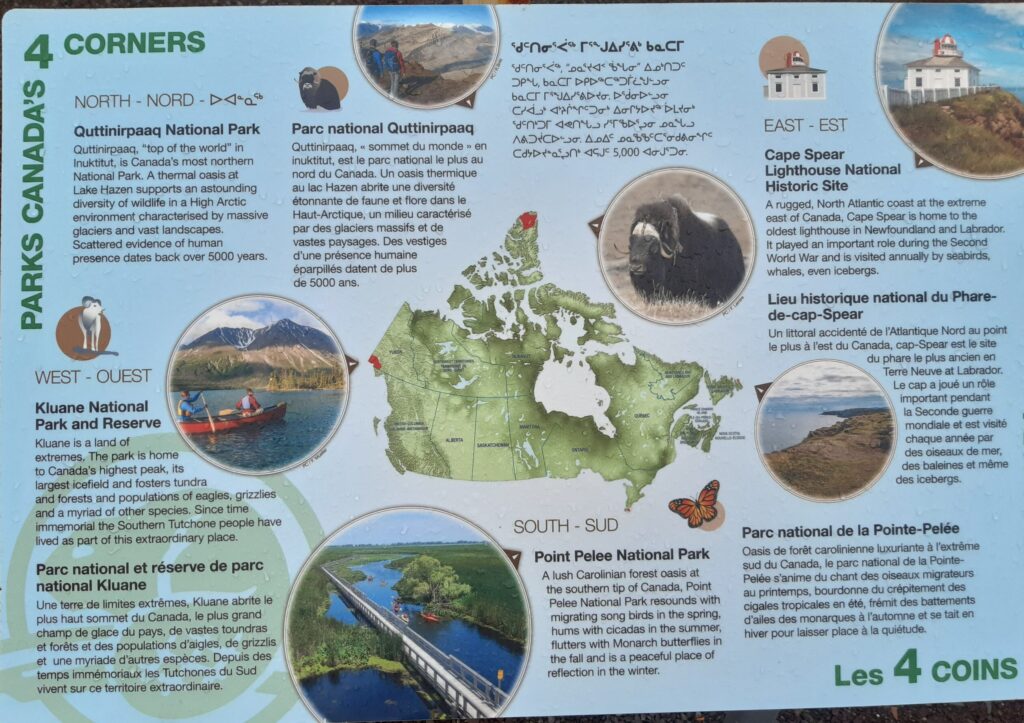
The map shows Canada’s other directional extreme points. A sign post at Cape Spear indicates that Quttinirpaaq National park is 4000 km distant to the north. Kluane National Park, on the Yukon Alaska border is 5500 km west and Point Pelee National Park, the southernmost point is 2400 km distant. All of the Yukon border, which I crossed when cycling back from Alaska, is in fact the westernmost point.

Cape Spear is on the Avalon Peninsula off the bottom corner of this map. Now I must retrace some of my previous route to reach the highway junction that goes to Bay L’Argent. The map shows the route I will take and the ferries I will board to get me back to Burgeo. The ferries don’t take cars although by special arrangement they would take a motorcycle.

Leaving Bay L’Argent. The first of the three ferries that I will take to reach Burgeo. Very nice to take a break from peddling and just enjoy the scenery.

The last ferry used. The towns on this route have no road access. Everything must be brought in by boat.

I don’t know what they are called but it’s the the knob extension that sits just below the waterline at the bow of the boat. The waters, for the most part, were very calm and I was able to stand at the bow. (I believe the purpose is to reduce the size of the wave produced.) Calm waters even though from the south coast of Newfoundland, in a SSE direction, there is 15,000 kilometres of unobstructed ocean to the coast of Antarctica.

A tourist site photo of Francois. A very unique place. The ferry docked for the night. I climbed the boardwalks, that act as roads for pedestrians and ATV’s, and pitched my tent at the upper outskirts of the town. I feel privileged to have been able to visit Francois and would have liked to be able to spend more time there.

Newfoundland is called the Rock for a very good reason and my tent pegs were often replaced by rocks as a means of holding the tent in place. Cycling north from Burgeo I was needing a spot to camp for the night but wasn’t finding anything decent. Sensing my need, a vehicle stopped and I was told there was a pond with a sandy beach right beside the highway a few kilometres ahead. I took him at his word and peddled on but I really believed it couldn’t be possible. Believe me this is one very rare bit of sandy beach.

It’s September 1st and after two months, I have reunited with the canoe, in Deer Lake. My loop of the island has taken longer than I expected. Next is the Northern Peninsula and eventually a ferry ride across to the Quebec Labrador, north side of the Gulf.

A first and last paddle of Atlantic waters in Newfoundland. It was nice to be back on the water even if it was for only 12.5 kilometres and into a head wind for most of the day. It was a bay I was paddling in not exposed to ocean swell. Once beyond this bay I would be in the Gulf of St. Lawerence where I could expect to have days spent wind bound and could also have surf to deal with.

My route on the Northern Peninsula. I pulled the canoe to Saint Barbe, the terminal for the ferry that crosses the Gulf to Quebec. (Easy enough to find someone willing to have me leave it in their yard while I continued with the bike only.) There were two areas of interest to me further north on the Peninsula. L’Anse aux Meadow where the Viking, Leif Eriksson, established a colony around 1000 AD and the town of St. Anthony, the home base of Sir Wilfred Grenfell, a British doctor/missionary who devoted his life to improving the lives of the inhabitants of Labrador and Northern Newfoundland. My knowledge and interest in both dated back to my elementary school days.

I first learned of Dr. Wilfred Grenfell from an account in a school reader of his remarkable survival when his dog sled sank after encountering mushy ice when he attempted to take a short cut across an ice covered bay. (Adrift on an Ice Pan) That story is now in the public domain and you are invited to read it here or listen to Grenfell’s telling here. It is an amazing account of survival brought about by him doing everything right when his otherwise chance of rescue was nil. Be aware though that that included the unfortunate necessity of killing three of his dog team.
