I spent two nights in Osoyoos preparing for the second leg of my journey – cycling from Osoyoos to Castlegar. Anarchist Mountain would be a test of my ability to haul everything over significant hills. Wishing to avoid an injury by taking on too much too soon, I elicited the help of my Osoyoos friend who agreed to drive to the Anarchist summit with all my gear … many thanks, Bill. While at Bill’s I also boxed up seventy pounds of unneeded equipment for shipment by bus to Castlegar. It took four hours of slow grinding to reach the summit. I did take some walk breaks but only to change things up. The gearing was low enough to allow riding up all the grades with only the canoe and cart in tow.
Viewpoint overlooking Osoyoos Lake.
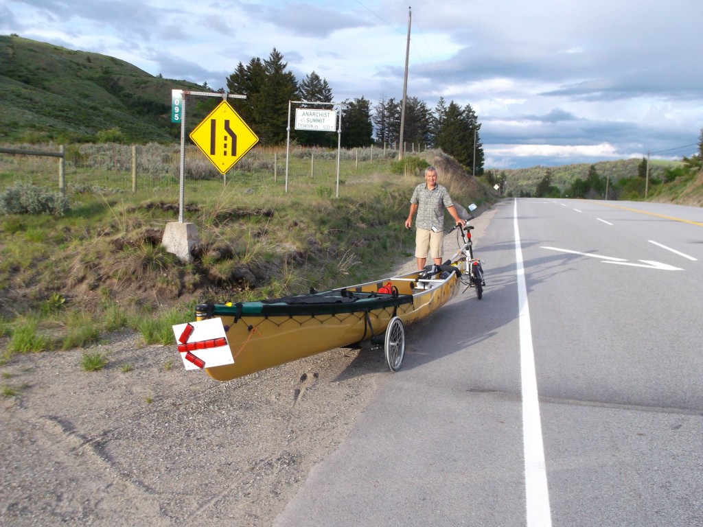
Anarchist Summit. Here I loaded the gear, including the 70 pound box I’d be shipping by bus from Rock Creek, into the canoe, and started down. I didn’t know how the bike brakes would handle the load and wondered what speed would be best for the descent. I knew the canoe and cart were very stable going downhill, so I reasoned that perhaps not using any brakes might be better than trying to control the speed. The no brake descent down Anarchist was rather nerve-wracking at first, as speeds above 60 kph were reached, but it convinced me that ‘letting er rip’ was the best way to do all my descents.
I arrived in Rock Creek at dusk and dropped the unneeded gear off at the Greyhound agents for shipment to Castlegar. From my forestry days, I knew of a nearby spot to spend the night and quickly made a simple shelter before dark.
Easy grades and light winds through the morning made for an enjoyable first half of the day. The true highlight of the day though was at a grocery stop at the supermarket in Midway. A four-year-old ball of ringlets left her mother behind and ran to where I was. She was really impressed with my ‘big boat’ and running her hands over it she looked at me and said: “Can I go wit u!” Would like to know the dreams she’s dreaming of now and where they will one day lead her.
Rain started past noon and continued on and off all day. The rain gear works though and I don’t find it unpleasant to ride in the rain. Heavier rain, coming into Grand Forks, did have me using the brakes on some of those downhills. I arrived in Christina Lake near dark and was soon riding in the dark by the light of my headlight as I began the climb up the Blueberry Paulson highway. It was my thought to make it to the highway’s gravel pit where I knew there was an open-fronted quonset building, used for storing road salt, where I could spend a dry night. Opted though to stop at a closer rest area where the tarp was again put to use to make a shelter using a picnic table.
My memory had it that the steep sections of the Blueberry Paulson began just past the gravel pit but I was able to ride for a couple of hours before the real steep began. It was necessary to push the bike for two, half-hour periods, on sections above and below the bridge. I didn’t keep track of how long it took to get up the 20 km Paulson grade but it remains the steepest grade of any pass I traveled with the canoe in tow.
The long grade up. I call heading uphill ‘winding the spring’ as there’s always payback – unlike a contrary breeze.
And every inch earned.
During my GPS traverse years, I did a lot of work in the Paulson area. I always rated this cut block as having the steepest slopes of any I did anywhere. This was the first time I’d seen it logged.
The Paulson Bridge. It shakes noticeably when you’re on it and a truck rumbles by.
The only break from the steep grades in the 20 km climb to the top – still another 400m elevation and 6 km to go though.
Not the summit but as good as – it’s the end of the 7% grades. The Paulson grade was the toughest of any of the summer’s summits.
A reference point on a cut block, adjacent to the highway, that I blazed flagged and painted more than ten years ago.
The grade was not a lot of fun going up but the nice part was the way the elevation was dispensed once past the summit. There were very few real steep downhills; instead, there were long sections with just enough down to allow me to pedal in my highest gear. The final grade into Castlegar is steep and with the roads dry I let her fly. Don’t know my max speed but expect I was doing better than 40 mph.
Stayed put in Castlegar for a full week enjoying my cousin’s hospitality.